Walking along the Rheinsteig
The Rheinsteig
in the World Heritage
Upper Middle Rhine Valley
leads in 8 stages
from Rüdesheim to Koblenz
passing the legendary Loreley
and many castles and palaces.
For visiting castles
the purchase of the Castle-Ticket
is recommended.
Rheinsteig: Rüdesheim - Lorch
12.18 Miles - 1421 feet in height - 5:15 h
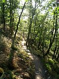
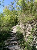
From the famous "Drosselgasse" in Rüdesheim you take the chair lift up to the Niederwalddenkmal, the start of the walking tour. After passing the hunting lodge "Niederwald" you go downhill to the city of Assmannshausen on Rhine. This city is famous for its red wine called "Höllenberg" and for its wonderful half-timbered buildings. Then the walking tour leads over rocky paths along the slope and through some narrow side valleys towards the city of Lorch.
Rheinsteig: Lorch - Kaub
8.33 Miles - 1591 feet in height - 3:45 h
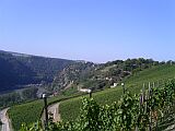
After Lorch the walking tour passes the castle ruin Nollig and leads steeply uphill through small forests and vineyards with wonderful views of the city of Bacharach with Stahleck Castle and Pfalzgrafenstein Toll Station. After passing Gutenfels Castle you walk steeply downhill to the city of Kaub.
Rheinsteig: Kaub - St.Goarshausen
13.92 Miles - 2717 feet in height - 6:00 h
This stage is the highlight of the whole Rheinsteig walking tour.
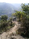
!!! You should be absolutely free from giddiness. The Rheinsteig leads first for a long time steeply uphill to the plateau above the Rhine river to the small city of "Dörscheid". Here at the latest you should stock up on enough beverages.
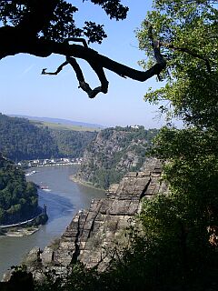
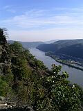
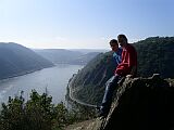
From the Rheinsteig trail you get many wonderful views: from the "Rossstein" you can admire the city of Oberwesel with Schönburg Castle and from the "Spitznack" you have a wonderful view of the Loreley.
Through the vineyards you reach the world-famous Loreley rock. In the Loreley visitors' centre on the Loreley plateau you can gen up on the Upper Middle Rhine Valley World Heritage.
On the walking tour to the Loreley city of St.Goarshausen you pass Katz Castle, which cannot be visited unfortunately.
Rheinsteig: St.Goarshausen - Kestert
7.58 Miles - 1801 feet in height - 4:15 h
From the Hasenbachtal in St.Goarshausen you walk steeply uphill with wonderful view of the city of St. Goar with Rheinfels Fortress till reaching Maus Castle. There you can visit an Eagles and Falcons Park. Worth seeing! Then you walk through the Pulsbachklamm (a gorge) to the city of Kestert.
Rheinsteig: Kestert - Osterspai
10.38 Miles - 1535 feet in height - 5:15 h
On a steep route to Liebenstein Castle and Sterrenberg Castle (the hostile brothers), then walking downhill to the city of Osterspai. On this walking tour you can admire two spectacular close bends of the Rhine river, as well as picturesque views of the cities of Kamp Bornhofen and Boppard.
Rheinsteig: Osterspai - Braubach
7.08 Miles - 1362 feet in height - 3:30 h
On this fairly short stage you walk along the largest Rhine loop which is located between the cities of Osterspai and Braubach. Then the walking tour passes Marksburg Castle, the only hilltop castle that has never been destroyed (worth seeing!) and leads downhill to Braubach with its nice half-timbered buildings.
Rheinsteig: Braubach - Oberlahnstein
5.16 Miles - 1165 feet in height - 2:45 h
A short stage of the Rheinsteig walking tour again with a beautiful view of the Marksburg Castle leads further away from the Rhine till finally arriving at the river Lahn. Along the river Lahn you can continue to the Rhine river till the city of Lahnstein (Oberlahnstein) to enjoy the view of Lahneck Castle and to stop at the famous "Wirtshaus an der Lahn".
Rheinsteig: Oberlahnstein - Koblenz
8.33 Miles - 1325 feet in height - 3:45 h
The highlight of the last stage of the walking tour is the "Rupertsklamm" (a gorge). The rocky ascent through the wild ravine is strenuous. At the highest point, the "Lichterkopf", you have in clear weather a wonderful panoramic view. The route leads through the "Bienhorntal" downhill to the Rhine river. Along the bank of the river to Koblenz with the mighty Ehrenbreitstein Fortress and the Deutsches Eck. The Rheinsteig walking tour in the Upper Middle Rhine Valley World Heritage ends here.
Current Loreley
Loreley guided tours
Tour „Enchanting Loreley”
Tour „Enchanting Loreley” including nature hike and wine tasting
Registration Loreley Tours
Fon: +49 (0) 6774 – 745
Fax: +49 (0) 6774 – 8174Mail: info@tempus-rhenus.de
Deutschland Germany information
Rhein river information
Loreley Info now mobile
|
|||||
| Source: Foto Loreleyfelsen Felix König | © 2006 - 2014 go_on Software GmbH |
||||